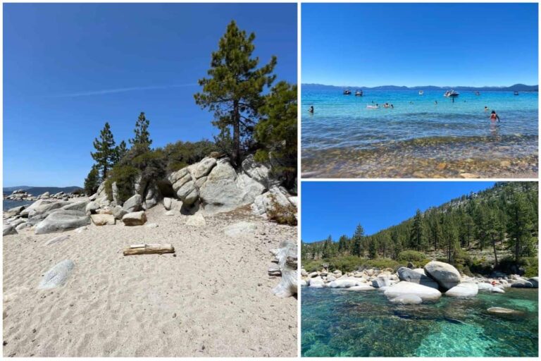
The Tahoe East Shore Trail is a picturesque walking and biking path that runs along the eastern shores of Lake Tahoe in Nevada. The 3-mile trail has incredible views for its entire duration and offers access to a number of public beaches. It’s one of the most amazing ways to explore the northeastern Tahoe area.

Where is the Tahoe East Shore Trail?
The Tahoe East Shore Trail is a 3-mile walking and biking path that runs along the eastern shore of Lake Tahoe in Incline Village, Nevada. The trailhead is located on Tahoe Blvd, at the intersection of Lakeshore Blvd. There are two large pay parking lots on Tahoe Blvd on either side of Ponderosa Ranch Rd. This is also where the Tunnel Creek Trailhead is that leads to Monkey Rock.
The “Impossible Trail”
The 3-mile trail was completed in 2019 but not without its fair share of hiccups. Commonly referred to as the ‘impossible trail’, “despite only being 3 miles long, this project has taken decades to accomplish – requiring the integration of multiple federal, state, and local governments”[1]. The completion of the trail created unparalleled opportunities to explore the shores of Lake Tahoe in a way that wasn’t possible before, with unobstructed views, and several public beach access points.

Beginning the Journey Along the Trail
I began my journey on the East Shore Trail on a sunny September morning. It being a weekday, the trail wasn’t overly busy, though I did see many passers-by on foot and on bicycles. The initial stint of the trail runs right along Tahoe Blvd but soon diverts to the right with a slight climb so that you are eventually looking over the street below.

Just after a few minutes on the trail, you begin to see what’s in store for you, with incredible views of Crystal Bay. The California-Nevada border is just at the peninsula across the water. The first quarter mile is a bit steep in some areas but begins to level out as you approach the half-mile mark.

The Tahoe East Shore Trail is a shared pathway, so you can expect to see lots of cyclists. Stick to the right of the path and allow folks to pass on the left.

The 1-Mile Mark and Beyond
Approaching the 1-mile mark, the trail begins sloping downwards as it prepares to pass under the highway. You’ll come to a roundabout that leads through the tunnel pictured below, sending you out on the other side of Tahoe Blvd.

The remainder of the trail runs right along Lake Tahoe, with Tahoe Blvd on the left. Just as you come out of the tunnel, you’ll be at the 1-mile mark, which is also the entrance to Hidden Beach. A mile further down the path is Memorial Point Scenic Overlook, and one mile past that is Sand Harbor Beach and State Park.
Lovely Lookouts
There are plenty of places for you to stop along the path and rest, or just enjoy the view. You’ll see quite a few benches overlooking scenic views, and vista points with informational plaques about the history, and geography of the east Tahoe area.


Beach Access on the Tahoe East Shore Trail
There are a total of 11 public beach access points[2] along the Tahoe East Shore Trail. Some of these beaches would otherwise be very difficult or even unsafe to reach. Now the access points have clearly marked trails or stairs leading to 2 very popular, and 9 other more secret beach destinations for your enjoyment.

Hidden Beach
The first beach along the trail is Hidden Beach, which isn’t so hidden. This beach is popular and can become very busy in the summer. It’s a gorgeous little sandy beach that looks west over Lake Tahoe. On either side of the beach are large boulders formations that jut out into the water. The boulders are a popular place to jump off into the water, to sun on, or just get a great picture. Hidden Beach is a great little spot, definitely one of my top 3 favorite beaches in the area.

Sand Harbor Beach
The Tahoe East Shore Trail ends at Sand Harbor Beach, 3 miles away from where the trail begins. Sand Harbour is among the most popular beaches and parks in the area. Sand Harbor is a massive sandy beach, stretching over 2000 feet long. It is very well maintained, and there is lots more to do in the area with a concession, a restaurant, watersport rentals, and other amenities right in the park! There is an entrance fee for the park, so keep that in mind if you decide to end your hike with a stop at Sand Harbor.

Other Beach Access Points
Besides the two main beaches, there are 9 other beach access points along the trail. Most of these are smaller rocky beaches, or boulder outcroppings, but they are much more private, and you can get some epic views, especially when climbing up onto the boulders. I checked out one of these smaller beaches, pictured below and climbed up the tallest flat boulder, and enjoyed the view for a while. There are tons of great spots like this along the shore.

Fauna and Flora Along the Trail
The Tahoe Area is part of a boreal forest, so the surrounding trees are coniferous, mostly Jeffrey and Sugar Pines. There is also a variety of shrubs and flower bushes, like the yellow rubber rabbitbrush pictured in the image below. Along the trail, you’ll also likely see plenty of chipmunks, squirrels, Steller’s Jay’s, and brewer’s blackbirds. You can also often find small lizards sunning on the rocks along the walking path.

FAQs About the Tahoe East Shore Trail
Is the Tahoe East Shore Trail difficult?
No, the Tahoe East Shore Trail is not difficult. It is a paved pathway, so it’s also very easy for biking. There are also spots to stop and rest along the trail, lookout points, and beach access points, so you certainly don’t have to do the entire 3 miles to get the most out of this trail.
Can you bike on the Tahoe East Shore Trail?
Yes, this trail is a shared path. It is a very popular spot for cycling. You can ride a bike along the path, but you must yield to walkers.
Is there parking at the Tahoe East Shore Trail?
The parking lot for the Tahoe East Shore Trail is located on Tahoe Blvd and Ponderosa Ranch Rd.
Are there restrooms on the Tahoe East Shore Trail?
There are restrooms at the trailhead, at the southern end of the parking lot. There are also public restrooms at the entrance to Hidden Beach, the Memorial Point Scenic Overlook, and at Sand Harbor Beach. So essentially there are rest stops at the trailhead, 1-mile, 2-mile, and 3-mile mark.
Article Sources:
- Tahoe Fund. “Tahoe East Shore Trail: What To Know Before You Go“
- Travel Nevada. “Tahoe East Shore Trail“


